The navigation and field-info app, built for the exceptional
The digital companion to your route surveys. Designed for road professionals, the app supports drivers, pilot cars, motorcycle escorts, operators and independents day to day.


Everything you need for exceptional transport
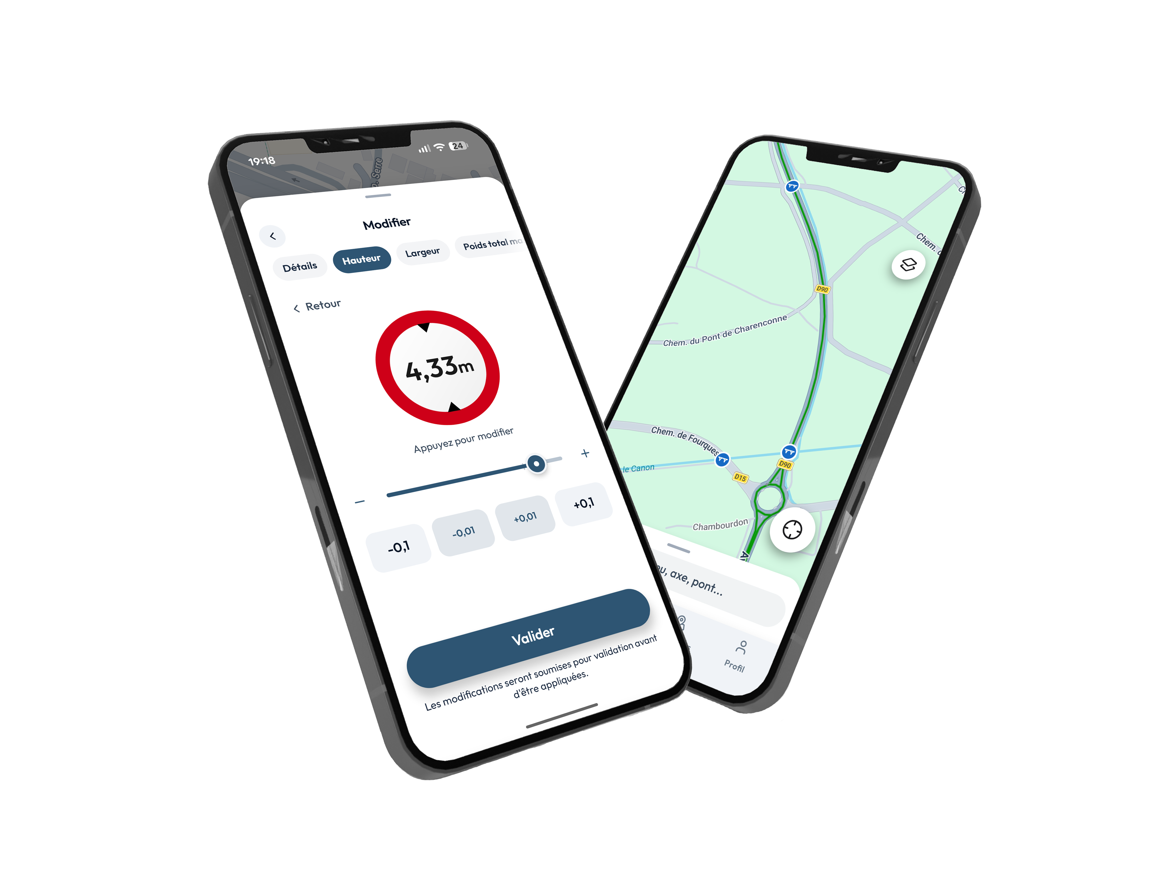
Specialised GPS guidance
Follow your validated route exactly. Immediate alerts if you leave the route.
Manual route creation
Draw your own route using community data and the TE networks.
TE prescriptions in one tap
Tap any point on your route to instantly see the regulatory prescriptions that apply – PP reference, authorised dimensions, notice period, manager contact.
Access to TE networks
Smart filters to clearly display the 1TE, 2TE48, TE72, TE94 and TE120 networks.
 Route d'Angoulême2 passages
Passage register
View anonymously the latest convoys that passed this spot along with their characteristics.
Advanced clearance search
Filter structures by height, width, weight or axle load to identify at a glance those compatible with your convoy.
Field reports & alerts
Roadworks, structure damage, damaged road surface, temporary obstacle – report and receive alerts from other professionals in real time.
Share a route easily
Share your route in one click with your colleagues or the field team via a secure link.
Rangefinder
Contributing to the community marker
Enrich the map by adding your measurements, photos and field feedback. Each contribution improves accuracy for all users.
Adapted to every player in exceptional transport
Enrich the map for everyone
The 140,000 structures listed in Convigo are maintained by professionals like you. Every corrected measurement, every photo added, every hazard reported improves accuracy for the next convoy.
Update structures
Enter a bridge's height, a tunnel's width, the max weight or axle load. Indicate the source so others know where the value comes from.
- Official B12 sign on site
- Personal measurement (laser, gauge pole...)
- Official document (plan, decree, permit)
Enrich the map
Add a photo on a structure, leave a comment, or view the latest convoy passages. Every field report completes the record for those who come after you.
- Photos of the structure and its surroundings
- Public comments on passage conditions
- History of previous convoy passages
.jpg) RD982 • Bridge
RD982 • Bridge
"If I'm not mistaken, 4,60m I think. I've already gone through with a forestry carrier by changing lanes because it's at an angle."
Report hazards
Road surface deformation, roadworks in progress, damaged cornice, temporary obstacle – report them to protect the convoys coming behind you. Your alerts appear on the map in real time.
- Roadworks affecting width or access
- Structure damage (cornice, crash barrier)
- Damaged road surface (bumps, potholes)
- Obstructing elements (branches, debris, obstacles)

Logistics Management & Planning
- Prepare and optimise your routes with all TE clearance constraints built in
- Instantly share validated routes and instructions with your field teams

Field Navigation & Safety
- Clearly view the prescriptions and obstacles listed along your route
- Navigate with peace of mind thanks to dedicated GPS guidance
Search for bridge heights on specific road axes
Filter community markers by type, clearance and road axis. In seconds, identify all the bridges and height constraints that affect your convoy.
Reliability and Expertise
Reliability and Expertise. Your field experience is authoritative.
Your field feedback builds your reputation and keeps everyone's network safe.
A documented passage might just be the detail that prevents an incident for someone you'll never meet.
Enjoy Convigo Plus right now with a 7-day free trial included
Convigo Plus
New plans are coming
We're preparing other offers tailored to different profiles. Stay tuned.
The road and its challenges – nobody knows them better than you
Join the group to share your feedback on the app, follow new features and chat with other members of the community.

Exceptional convoy passing through: crossing Lozère under way!

